GovBot.ai
All maps

#30DayMapChallenge · Day 8 · Utopia · Sunday 8 November 2026

Mitigation actions in Harris County’s hazard mitigation plan
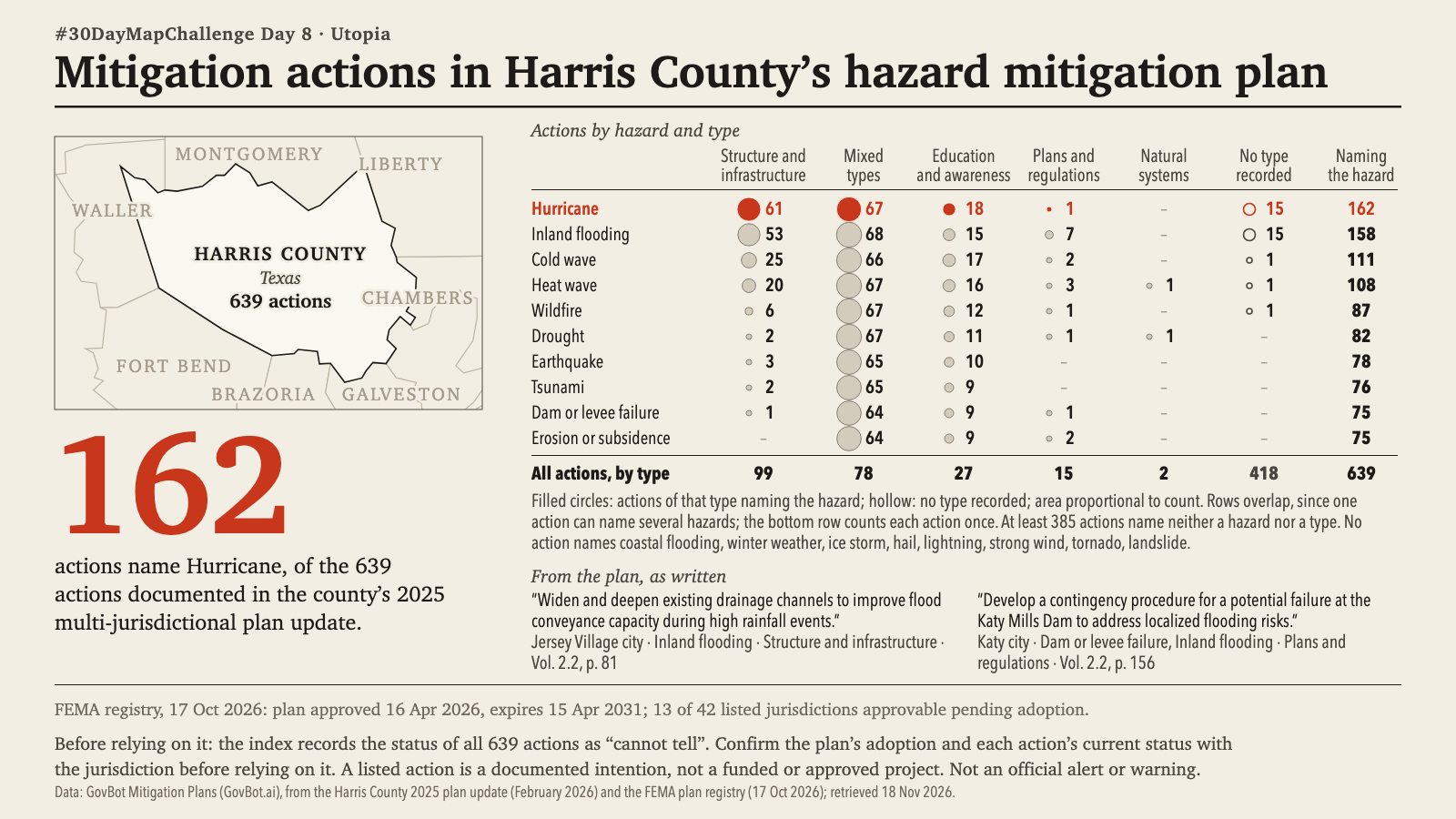
Print layout on a cream ground. Small map of Harris County, Texas, outlined in black among labelled neighbouring counties (Montgomery, Liberty, Chambers, Galveston, Brazoria, Fort Bend, Waller), marked 639 actions. The headline figure, 162 in large vermilion type, reads: actions name Hurricane, of the 639 actions documented in the county's 2025 multi-jurisdictional plan update. A table lists actions by hazard (rows) and type (columns), with circles sized by count; the Hurricane row is in vermilion: structure and infrastructure 61, mixed types 67, education and awareness 18, plans and regulations 1, no type recorded 15, naming the hazard 162. Other rows: inland flooding 158, cold wave 111, heat wave 108, wildfire 87, drought 82, earthquake 78, tsunami 76, dam or levee failure 75, erosion or subsidence 75. Totals by type: 99, 78, 27, 15, natural systems 2, no type recorded 418; 639 in all. Two quotations from the plan are given with page references, from Jersey Village city (Vol. 2.2, p. 81) and Katy city (Vol. 2.2, p. 156). The FEMA registry, 17 Oct 2026, lists the plan as approved 16 Apr 2026, expiring 15 Apr 2031, with 13 of 42 listed jurisdictions approvable pending adoption. A note says the index records the status of all 639 actions as cannot tell and that a listed action is a documented intention, not a funded or approved project. Printed: Not an official alert or warning.

Animation: the table rows appear hazard by hazard, top to bottom, each with its counts by activity type; the column totals and notes return last. The order is a reading order, not a sequence in time; no value changes. 19 seconds, with sound; the player starts muted. Still image · Animation file (MP4)
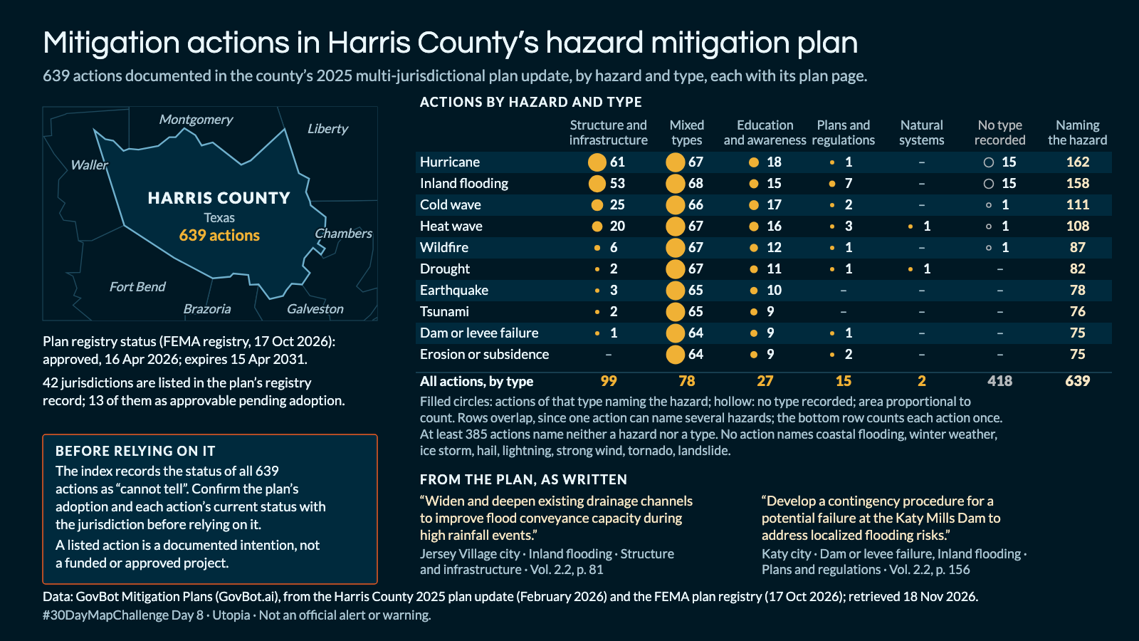
Animation: the table rows appear hazard by hazard, top to bottom, each with its counts by activity type; the column totals and notes return last. The order is a reading order, not a sequence in time; no value changes. 19 seconds, with sound; the player starts muted. Still image · Animation file (MP4)

What mitigation actions does the Harris County, Texas hazard mitigation plan document, by hazard and activity type, and on which plan pages?

In Claude, add "GovBot Mitigation Plans"; in ChatGPT, add "GovBot Mitigation Plans" once, then turn it on in the chat. Every listing is at govbot.ai.

Data: GovBot Mitigation Plans (GovBot.ai), from the Harris County 2025 plan update (February 2026) and the FEMA plan registry (17 Oct 2026); retrieved 18 Nov 2026.

How it was made: Data from the GovBot listing named above; map made with Claude, an AI model, and reviewed before publication. The animation shows the same records as the still image, and begins and ends on it.

Add it once

Claude: Settings, Connectors, then the GovBot listing in the connector directory. ChatGPT: search the plugin directory for the GovBot listing.

Turn it on in the chat

In Claude, switch the listing on in the chat. In ChatGPT, type @ in a new chat and choose it. Developers can use the same Claude listings in Claude Code.

Ask in plain language

Ask in plain language. Check the sources, record dates and stated limits in the answer.